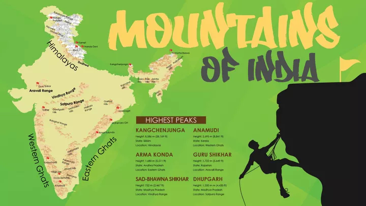
| State | Peak | Range/Region | Height (m) | Height (ft) |
| Andhra Pradesh | Arma Konda | Eastern Ghats | 1,680 | 5,512 |
| Arunachal Pradesh | Kangto (shared with Tibet)( Kangto lies on the Arunachal Pradesh-Tibet borde) | Eastern Himalaya | 7,090 | 23,261 |
| Assam | Unnamed peak near Laike | Dima Hasao District | 1,960 | 6,430 |
| Bihar | Someshwar Fort | West Champaran District | 880 | 2,887 |
| Chhattisgarh | Bailadila Range(The highest named peak is Gaurlata (1225 m) | Dantewada District | 1,276 | 4,186 |
| Goa | Sosogad | Western Ghats | 1,022 | 3,353 |
| Gujarat | Girnar | Junagadh District | 1,145 | 3,756 |
| Haryana | Karoh Peak | Morni Hills | 1,499 | 4,918 |
| Himachal Pradesh | ReoPurgyil (shared withTibet)( ReoPurgyil lies on the Himachal Pradesh-Tibet border) | Western Himalaya | 6,816 | 22,363 |
| Jammu and Kashmir(claimed) | K2 (K2 lies in Pakistan Administered Kashmir, which is claimed by India as part of Jammu and Kashmir.) | Karakoram | 8,611 | 28,251 |
| Jammu and Kashmir(administered) | Saltoro Kangri (Saltoro Kangri lies along the AGPL in the Siachen area.) | Karakoram | 7,742 | 25,400 |
| Jharkhand | Parasnath | Parasnath Hills | 1,366 | 4,482 |
| Karnataka | Mullayanagiri | Western Ghats | 1,925 | 6,317 |
| Kerala | Anamudi | Western Ghats | 2,695 | 8,842 |
| Madhya Pradesh | Dhupgarh | Satpura | 1,350 | 4,429 |
| Maharashtra | Kalsubai | Western Ghats | 1,646 | 5,400 |
| Manipur | Mount Iso (Tenipu) | Senapati District | 2,994 | 9,823 |
| Meghalaya | Shillong Peak | Khasi Hills | 1,965 | 6,447 |
| Mizoram | Phawngpui | Saiha District | 2,165 | 7,103 |
| Nagaland | Mount Saramati (Shared withMyanmar) (MountSaramati lies on the Nagaland-Myanmar border.) | Naga Hills | 3,841 | 12,602 |
| Odisha | Deomali | Eastern Ghats | 1,672 | 5,486 |
| Punjab | Unnamed point on the NainaDevi range | Rupnagar District | 1,000 | 3,281 |
| Rajasthan | Guru Shikhar | Aravali | 1,722 | 5,650 |
| Sikkim | Kangchenjunga (Shared withNepal) (Kangchenjunga lies on the Sikkim-Nepal border) | Eastern Himalaya | 8,598 | 28,208 |
| Tamil Nadu | Doddabetta | Nilgiri Hills | 2,636 | 8,648 |
| Telangana | Laxmidevipalli | Deccan Plateau | 670 | 2,198 |
| Tripura | Betalongchhip | Jampui Hills | 1,097 | 3,600 |
| Uttar Pradesh | Amsot Peak | Shivalik Hills | 957 | 3,140 |
| Uttarakhand | Nanda Devi | Garhwal Himalaya | 7,816 | 25,646 |
| West Bengal | Sandakphu (Shared with Nepal) (Sandakphu lies on the West Bengal-Nepal border) | Eastern Himalaya | 3,636 | 11,929 |
| Union Territories | ||||
| State | Peak | Range/Region | Height (m) | Height (ft) |
| Andaman & Nicobar Islands | Saddle Peak | North Andaman Island | 732 | 2,402 |
| Chandigarh | Unnamed point | Capital Area | 383 | 1,257 |
| Dadra and Nagar Haveli | Unnamed point | Amboli | 278 | 912 |
| Daman and Diu | Unnamed point | Diu | 30 | 98 |
| Delhi | Unnamed point | Tughlaqabad | 319 | 1,047 |
| Lakshadweep | Unnamed point | Agatti Island | 15 | 49 |
| Puducherry | Les Montagnes Rouges | Red Hills | 30 | 98 |
Most Important Mountain Passes in India state wise:
- In a group of hills or mountains, a pass is a path for crossing a mountain. Many of the world’s mountain ranges have always made travel difficult so passes have been important throughout history in trade, war and migration.
Here is the list of Important Mountain Passes in India state wise:
| State | Mountain Passes |
| Jammu and Kashmir (Ladakh) | Changla Pass, Dehra Compass, Fotu La, Khardung La, Kongka Pass, Lanak Pass, Karakoram Pass, Lungalacha La, Marsimik La, Namika La, Pensi La, Rezang La, Sasser Pass, Shingo La, Spangur Gap, Tanglang La |
| Jammu and Kashmir (Siachen Glacier) | Sia La, Gyong La, Bilafond La |
| Jammu and Kashmir (Jammu, Kashmir) | Banihal Pass |
| Jammu and Kashmir (Kashmir, Ladakh) | Zojila Pass |
| Himachal Pradesh | Bara-lacha-la (Zanskar range, along the Leh–Manali Highway), Chanshal Pass (Shimla), Debsa Pass, Indrahar Pass, Kunzum Pass, Lamkhaga Pass, Rohtang Pass, Shipki La (on the India-China border) |
| Uttarakhand | Auden’s Col, Lipulekh Pass, Mana Pass, Nama Pass, Sin La, Traill’s Pass |
| Sikkim | Dongkhala, Goecha La, Jelep La, Nathu La |
| Arunachal Pradesh | Bomdila, Diphu Pass, Sela Pass |
| Rajasthan | Haldighati Pass |
| Madhya Pradesh | Asirgarh |
| Kerala | Palakkad Gap, Thamarassery, Sengottai |
Important Passes in South India
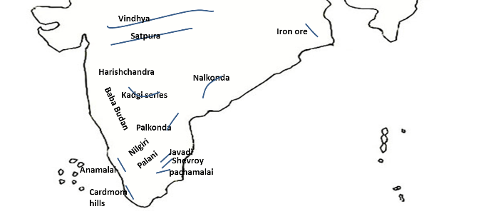
| Pass | Location | Connectivity |
|---|---|---|
| Bhorghat | Maharashtra | Bombay-Pune |
| Thalgat | Maharashtra | Bombay- Nasik |
| Palghat | Kerala | Palkhad – Coimbtore |
| Shenkota pass | Kerala | Kollam – Madurai |
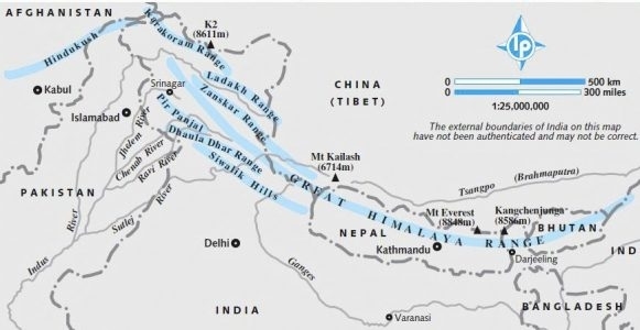
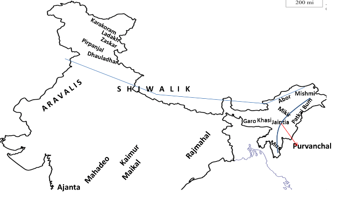
The three parallel ranges of Himalayas are:
Himadri (Great or Inner Himalayas)
- It is the most continuous range with an average height of 6000 meters.
- It remains covered with snow throughout the year.
Himachal (Lesser Himalayas)
- It lies to the south of Himadri.
- The average height of these mountains is between 3,700 to 4,500 meters.
- Famous ranges are: Pir Panjal range, Dhaula Dhar and Mahabharat ranges.
- Famous valleys like Kangra, Kullu, and Kashmir are situated in this valley.
Shivalik (Outer Himalayas)
- These are outermost ranges of Himalayas and have an average height between 900 to 1100 meters.
- These ranges are mainly composed of unconsolidated rock material, so these ranges are prone to earthquakes and landslides.
- The longitudinal valleys lying between lesser Himalayas and Shiwaliks are called ‘Duns’ like Dehra Dun, Kotli Dun, and Patlin Dun, etc.
Important Passes in Middle Himalaya
| Pass | Location | Connectivity |
|---|---|---|
| Pirpanjal Pass | Jammu and Kashmir | Jammu-Srinagar road passes from this Pass |
| Banihal Pass | Jammu and Kashmir | Jammu-Srinagar Nh-1A Passes from This pass. Jawahar tunnel (India’s longest road tunnel) is situated o this pass |
| Rohtang Pass | Himachal Pradesh | Kullu-Keylang road passes from this pass |
Important Passes in Inner Himalaya
| Pass | Location | Connectivity |
|---|---|---|
| Karakoram Pass | Jammu and Kashmir | India to China |
| Burzil Pass | Jammu and Kashmir | Kashmir Valley to Central Asia |
| Zojila Pass | Jammu and Kashmir | Srinagar to Leh |
| Bara Lacha-la Pass | Himachal Pradesh | Mandi to Leh |
| Shipki-la-Pass | Himachal Pradesh | Shimla to Garetok (Tibbet) |
| Mana Pass | Uttarakhand | Entry to Mansarovar Lake through kailash Ghati |
| Niti Pass | Uttarakhand | Entry to Mansarovar Lake through kailash Ghati |
| Lipulekhpass | Uttarakhand | Entry to Mansarovar Lake through kailash Ghati |
| Nathu-la-pass | Sikkim | Entry to Chumbi Valley |
| Jelep-la pass | Sikkim | Kalingpang (west Bengal) to Lhasa (tibet) |
| Bomdi-la pass | Arunachal Pradesh | Ar. Pradesh to Lhasa (tibet) |
| Yang-yap pass | Arunachal Pradesh | Entry to Brahmaputra river |
| Pangsad pass | Arunachal Pradesh | Dibrugarh to Myanmar |
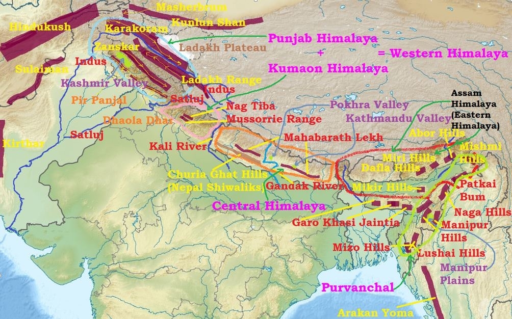
Important Mountain ranges in Himalayas:
The Main Himalayan Ranges are:
Pir Panjal Range
- located in Himachal Pradesh and Jammu and Kashmir
- Pir Panjal is the largest range of the lower Himalayas.
- Important passes in this range- Pir Panjal pass, Banihal pass
DhaulaDhar Range
- It is located in lesser Himalayas
Zanskar Range
- It is located in the state of Jammu and Kashmir and Uttarakhand
Ladakh Range
- It is a part of Karakoram Mountain.
Important hill stations of India:
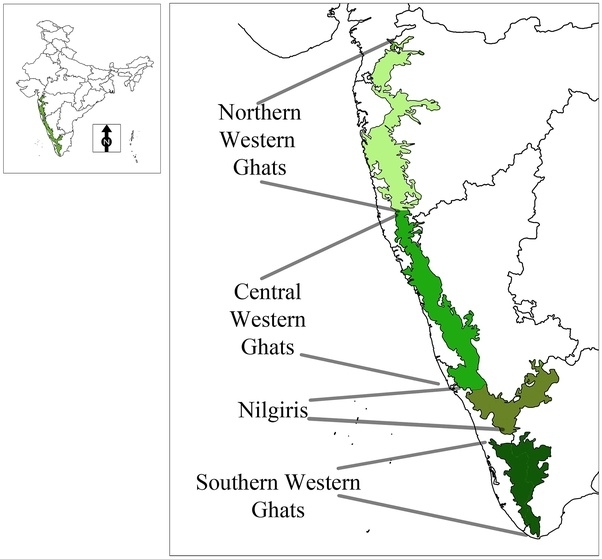
| Name of the hill station | Located in | Present in |
|---|---|---|
| Kodaikanal | Palani Hills | Tamilnadu |
| Manali | Kullu Valley | Himachal Pradesh |
| Mussoorie | Garhwal Hills | Uttarakhand |
| Ooty | Nilgiri Hills | Tamilnadu |
| Lonavla | Sahyadri Hills | Maharashtra |
| Nainital | Kumaon Hills | Uttarakhand |
| Darjeeling | Lesser Himalayas | West Bengal |
| Dalhousie | Dhauladhar range | Himachal Pradesh |
- Ooty is also known as Udagamandalam
- In Tamil, Kodaikanal means The Gift of the forest.
Important Passes in India:
| Name of the Pass | Located in | Pass connects |
|---|---|---|
| Shipki La | Himachal Pradesh | Simla with Tibet |
| Rohtang Pass | Himachal Pradesh | Manali and Lahul |
| Bhor Ghat pass | Maharashtra | Mumbai and Pune |
| Thal Ghat pass | Maharashtra | Nasik and Mumbai |
| Pal Ghat | Tamil Nadu | Kerala with Tamil Nadu |
| Nathula pass | Sikkim | Sikkim and Tibet |
Mountains And Hills
| Highest mountain in India | Kanchenjunga |
| The Highest peak in Aravallis | Guru Sikhar |
| Oldest Mountain range in India | Aravallis |
| Highest peak in Western Ghats | Anamudi |
| Highest peak in Eastern Ghats | Jindhagadha Peak |
| Mountains that divide Northern India from Deccan Plateau | Vindhyas |
Kanchenjunga is the third highest Mountain in the world. First two highest mountains in the world
1. Mount Everest- 8,848 mts
2. K2 also known as Godwin Austin- 8,611 mts
3. Kanchenjunga- 8,586 mts
1. Mount Everest- 8,848 mts
2. K2 also known as Godwin Austin- 8,611 mts
3. Kanchenjunga- 8,586 mts
- Guru Shikhar is located in near Mt. Abu in Rajasthan
- Meaning of Aravallis- Line of peaks
- Jindhagadha Peak is located in Andhra Pradesh. It has the height of 1,690 mts
Hill Ranges in India and their locations:
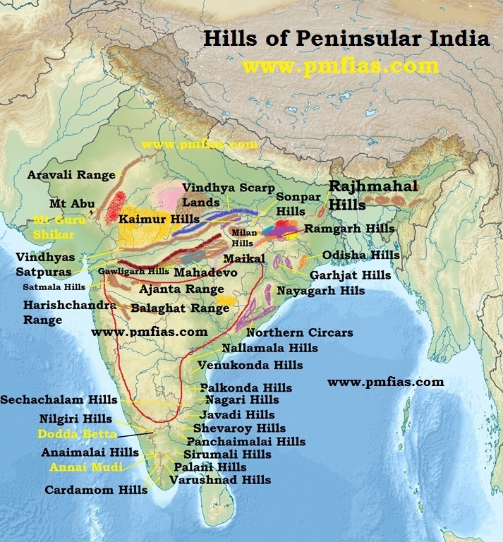
| Name of the Hill range | Present in states |
|---|---|
| Aravallis | Gujarat, Rajasthan, Haryana |
| Vindhyas | Gujarat, Madhya Pradesh, Uttar Pradesh |
| Eastern Ghats | Tamil Nadu, Karnataka, Andhra Pradesh, Odisha, West Bengal |
| Western Ghats | Tamil Nadu, Kerala, Karnataka, Goa, Maharashtra |
| Nilgiri Hills | Tamil Nadu, Kerala and Karnataka |
| Palani Hills | Tamil Nadu |
| Garo Hills, Kasi Hills and Jaintia Hills | Meghalaya |
| Anaimalai Hills | Kerala and Tamil Nadu |
| Cardamom Hills | Kerala and Tamil Nadu |
comment 0 Comments
more_vert